| Re: Storm Conall to bring more rain to parts of England and Wales - 26 Nov 2024 Posted by Chris from Nailsea at 19:06, 27th November 2024 |      |
An update, from the BBC:
Storm Conall brings more rain as it passes over UK
Storm Conall has brought another day of rain to southern England, causing disruptions including cancellations of train services.
There are currently 75 flood warnings in England with flood-hit areas still recovering from the days of downpours during Storm Bert.
The new storm broght fewer issues as it passed over southern England on Tuesday night and Wednesday morning, because it was forecast to strengthen as it moved towards the Netherlands.
The number of flood warnings is expected to continue dropping as the flood-hit areas will see drier weather over the next few days.
As Storm Conall passed over England, nearly 50mm of rain fell on Dartmoor and 20-30mm in some other parts of southern England.
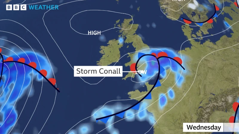
But many of the areas that were flooded during Storm Bert saw less rain with totals at around 3mm-8mm, so further problems were averted. The rain was linked to a developing area of low pressure crossing west to east across southern England. The upcoming days will see higher pressure, which will bring dry weather across flooded areas, allowing time for the flood water to disappear.
In parts of south-east England, trains were cancelled along three routes due to flooded tracks, while five other routes were facing disruption on Wednesday morning.
Gatwick Express trains will continue to see delays and cancellations into the evening, with the service advising commuters who use the service to start return journeys as soon as possible due to disruptions.
Thameslink passengers travelling to Welwyn Garden City have been advised to use alternate routes due to some suspended services, while others are still reduced.
...

Heavy rainfall and strong winds brought by Storm Bert over the weekend led to at least five deaths, while homes, roads and rail networks faced major disruption.
(news item continues)
Storm Conall has brought another day of rain to southern England, causing disruptions including cancellations of train services.
There are currently 75 flood warnings in England with flood-hit areas still recovering from the days of downpours during Storm Bert.
The new storm broght fewer issues as it passed over southern England on Tuesday night and Wednesday morning, because it was forecast to strengthen as it moved towards the Netherlands.
The number of flood warnings is expected to continue dropping as the flood-hit areas will see drier weather over the next few days.
As Storm Conall passed over England, nearly 50mm of rain fell on Dartmoor and 20-30mm in some other parts of southern England.
But many of the areas that were flooded during Storm Bert saw less rain with totals at around 3mm-8mm, so further problems were averted. The rain was linked to a developing area of low pressure crossing west to east across southern England. The upcoming days will see higher pressure, which will bring dry weather across flooded areas, allowing time for the flood water to disappear.
In parts of south-east England, trains were cancelled along three routes due to flooded tracks, while five other routes were facing disruption on Wednesday morning.
Gatwick Express trains will continue to see delays and cancellations into the evening, with the service advising commuters who use the service to start return journeys as soon as possible due to disruptions.
Thameslink passengers travelling to Welwyn Garden City have been advised to use alternate routes due to some suspended services, while others are still reduced.
...

Heavy rainfall and strong winds brought by Storm Bert over the weekend led to at least five deaths, while homes, roads and rail networks faced major disruption.
(news item continues)
| Storm Conall to bring more rain to parts of England and Wales - 26 Nov 2024 Posted by Chris from Nailsea at 22:05, 26th November 2024 |      |
From the BBC:
A newly-named storm, Conall, is forecast to bring heavy rain to southern England and threaten further issues in flood-hit areas still cleaning up from Storm Bert.
The Met Office has issued yellow weather warnings for rainfall in several southern areas of the UK from 22:00 GMT on Tuesday until midday on Wednesday.
Many parts of England and Wales will also see wet conditions overnight, though the worst of the storm will not hit the UK.
The storm was named by the Dutch Weather Service, which along with the Met Office and Met Eireann in Ireland, name storms for ease of communication.
BBC Weather's Tomasz Schafernaker said Conall would still be developing as it tracked across southern parts of the UK, meaning "the worst of the storm is expected to miss us". He said the rain would be "initially quite heavy", before moving east throughout the night.
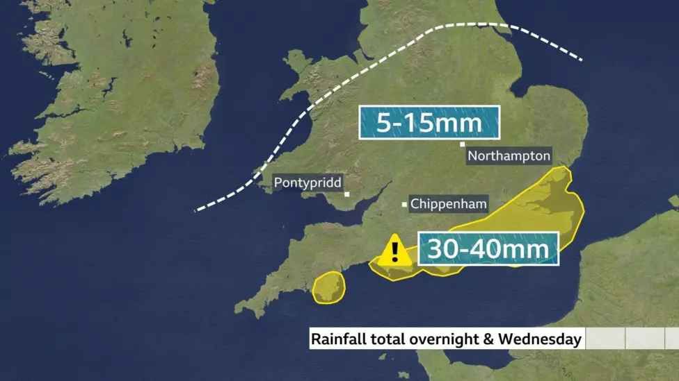
The heaviest rainfall is expected near the south coast of England and in the far southeast, with 15-20mm and possibly 30-40mm of rain forecast. These areas did not receive the same heavy rainfall from Storm Bert as some other parts of England and Wales.
Flood-hit areas, which could see some rainfall overnight, are very sensitive to any more rain. And while there will not be much, typically 5-15mm, it could cause more issues.

On Wednesday, the rain band is expected to curl back, with Lincolnshire, the Peak District and the Midlands likely to experience wet conditions, Schafernaker said.
Coastal areas of Norfolk, Suffolk, Essex and Kent could also feel "near gale force" winds. In the north, frost is expected in Scotland and the Lake District.
Heavy rainfall and strong winds brought by Storm Bert over the weekend led to at least five deaths, while homes, roads and rail networks faced major disruption. Many communities are still cleaning up after homes and businesses were inundated by floodwater.
Conall is the third "named" storm of the season, after Ashley and Bert.
The storms list - first launched in 2015 - for each year generally runs from early September until late August the following year, coinciding with the beginning of autumn.
The Met Office has issued yellow weather warnings for rainfall in several southern areas of the UK from 22:00 GMT on Tuesday until midday on Wednesday.
Many parts of England and Wales will also see wet conditions overnight, though the worst of the storm will not hit the UK.
The storm was named by the Dutch Weather Service, which along with the Met Office and Met Eireann in Ireland, name storms for ease of communication.
BBC Weather's Tomasz Schafernaker said Conall would still be developing as it tracked across southern parts of the UK, meaning "the worst of the storm is expected to miss us". He said the rain would be "initially quite heavy", before moving east throughout the night.
The heaviest rainfall is expected near the south coast of England and in the far southeast, with 15-20mm and possibly 30-40mm of rain forecast. These areas did not receive the same heavy rainfall from Storm Bert as some other parts of England and Wales.
Flood-hit areas, which could see some rainfall overnight, are very sensitive to any more rain. And while there will not be much, typically 5-15mm, it could cause more issues.

On Wednesday, the rain band is expected to curl back, with Lincolnshire, the Peak District and the Midlands likely to experience wet conditions, Schafernaker said.
Coastal areas of Norfolk, Suffolk, Essex and Kent could also feel "near gale force" winds. In the north, frost is expected in Scotland and the Lake District.
Heavy rainfall and strong winds brought by Storm Bert over the weekend led to at least five deaths, while homes, roads and rail networks faced major disruption. Many communities are still cleaning up after homes and businesses were inundated by floodwater.
Conall is the third "named" storm of the season, after Ashley and Bert.
The storms list - first launched in 2015 - for each year generally runs from early September until late August the following year, coinciding with the beginning of autumn.


