| ncredible new Thameslink 3D maps created showing London, Sussex and Bedfordshire Posted by ChrisB at 21:20, 19th November 2024 |      |
From MyLondon, via MSN
New 3D maps have been created for four train services that travel through London in order to help passengers travel through trains with more confidence. Thameslink trains to Gatwick and Luton Airports, as well as to Brighton and various London stations, will be included in the new maps.
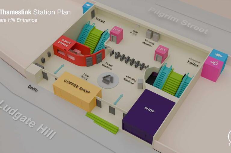
These new maps have been designed so that travellers can plan their journeys through stations in Sussex, Bedfordshire and London using their mobile phones. It will make it easier for disabled passengers to identify staircases, lifts, and ticket gates at each of the stations, Govia Thameslink (GTR) has said.
The train company say that currently, bird’s-eye-view maps exist of every station served by GTR, but these maps were not to scale and sometimes difficult to navigate at a glance, especially at larger stations. The new diagrams show colour-coded accessible routes, steps, and clearly show the various levels to a station.

The maps can be accessed through National Rail Enquiries, or on the website of all GTR’s train brands.
Carl Martin, Govia Thameslink Railway’s Accessibility Lead, said: "We understand that for some of our customers, visiting a new station can feel overwhelming.
“Whether it’s finding essential facilities or navigating between platforms, our goal is to ensure everyone can travel independently and with confidence, regardless of their access needs.
Full list of stations with 3D maps
The first 10 stations to be mapped in 3D are:
Brighton
City Thameslink
Denmark Hill
East Croydon
Elephant & Castle
Finsbury Park
Gatwick Airport
London Blackfriars
Luton Airport Parkway
Peckham Rye
These new maps have been designed so that travellers can plan their journeys through stations in Sussex, Bedfordshire and London using their mobile phones. It will make it easier for disabled passengers to identify staircases, lifts, and ticket gates at each of the stations, Govia Thameslink (GTR) has said.
The train company say that currently, bird’s-eye-view maps exist of every station served by GTR, but these maps were not to scale and sometimes difficult to navigate at a glance, especially at larger stations. The new diagrams show colour-coded accessible routes, steps, and clearly show the various levels to a station.

The maps can be accessed through National Rail Enquiries, or on the website of all GTR’s train brands.
Carl Martin, Govia Thameslink Railway’s Accessibility Lead, said: "We understand that for some of our customers, visiting a new station can feel overwhelming.
“Whether it’s finding essential facilities or navigating between platforms, our goal is to ensure everyone can travel independently and with confidence, regardless of their access needs.
Full list of stations with 3D maps
The first 10 stations to be mapped in 3D are:
Brighton
City Thameslink
Denmark Hill
East Croydon
Elephant & Castle
Finsbury Park
Gatwick Airport
London Blackfriars
Luton Airport Parkway
Peckham Rye


